
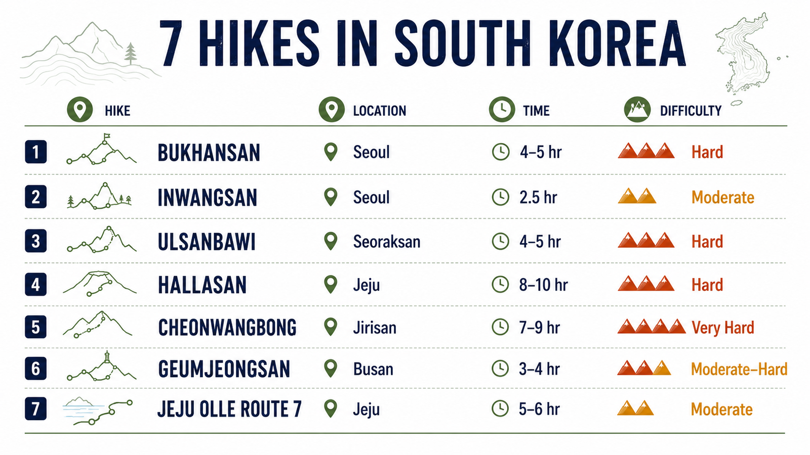
Distances depend on the chosen entrance and finishing point. Do not use these figures as substitutes for an official trail map.
How to Choose a South Korea Hiking Route
Choose by logistics and fitness rather than by mountain reputation alone.
- First mountain hike from Seoul: Bukhansan.
- Short hike without leaving Seoul: Inwangsan.
- Most dramatic granite scenery: Seoraksan.
- Highest summit: Hallasan.
- Most demanding day in this guide: Jirisan’s Cheonwangbong.
- Best mountain option from Busan: Geumjeongsan.
- Best non-summit walking experience: Jeju Olle Route 7.
Hallasan, Seoraksan and Bukhansan attract the most search interest, but they serve different travelers. Hallasan requires an early, highly structured day; Seoraksan works better with a night in Sokcho; Bukhansan is the easiest to incorporate into a Seoul itinerary.
Some trailheads are reached by city transit, while others require intercity buses and local connections. Our South Korea transportation guide explains the main networks and planning tools.
1. Bukhansan: Best Mountain Hike from Seoul
Bukhansan National Park Seoul offers the clearest combination of a substantial mountain hike and public transport access. Its best-known objective is Baegundae, the park’s highest peak at approximately 836 metres.
Several routes reach the summit area. One common approach begins near the Bukhansanseong entrance northwest of central Seoul. The hike passes forest, fortress remains and increasingly steep granite terrain before reaching the exposed final section.
The last approach to Baegundae uses fixed rails and cables across rock slabs. It is manageable for experienced hikers in dry conditions but can feel uncomfortable for people who dislike exposure. Rain, ice and heavy weekend traffic make this section more difficult.
Route profile
- Approximate distance: 7–8 km return, depending on the entrance.
- Time: around 4–5 hours.
- Difficulty: hard.
- Terrain: forest trail, stone steps and exposed granite.
- Best for: travelers wanting a serious mountain day without leaving Seoul.
Getting there
A common public transport approach uses Seoul Subway Line 3 to Gupabal, followed by a local bus toward the Bukhansanseong entrance. Bus numbers and stopping arrangements can change, so check Naver Map or KakaoMap on the day.
Another approach uses the northeastern side of the park near Bukhansan Ui Station. Do not assume that different trailheads lead to identical distances or difficulty.
What to check
- current trail closures;
- rain, wind or ice;
- the intended entrance and return route;
- sunset time;
- weekend crowd conditions.
Bukhansan can become heavily congested on clear autumn weekends. Start early on a weekday if possible.
Use the Korea National Park Service for current park notices rather than relying only on a travel blog.
2. Inwangsan and Seoul City Wall: Best Short Urban Hike
Inwangsan is a more practical choice when there is not enough time for Bukhansan. The official Seoul City Wall route crosses a rocky mountain ridge close to the historic center and provides views toward Gyeongbokgung, Namsan and northern Seoul.
The official Inwangsan section runs from the former Donuimun Gate area to Changuimun Gate.
According to the Seoul City Wall route guide, the complete section is:
- Distance: 4 km;
- Estimated time: about 2 hours 30 minutes;
- Format: point-to-point;
- Highest area: Inwangsan, approximately 339 metres.
Although the mountain is low, the route includes stairs, rocky surfaces and exposed sections. The official guide gives it its highest difficulty rating and recommends particular care during winter.
Why choose Inwangsan
- easy access from central Seoul;
- useful for a half-day itinerary;
- city and mountain views on the same route;
- no advance reservation;
- possible to combine with nearby historic neighborhoods.
This is not a wilderness trail. Sections pass roads, fortifications and urban areas, but that combination is precisely what makes it useful.
Avoid the exposed ridge during thunderstorms, strong wind or icy conditions.
3. Seoraksan Ulsanbawi: Best Granite Mountain Scenery
Seoraksan National Park South Korea contains everything from short valley walks to demanding ridge routes. For most first-time visitors, Ulsanbawi provides a good balance between dramatic scenery and a route that can be completed in one day.
The trail normally begins in the Sogongwon area near Sinheungsa Temple. It passes forest, temple-related sites and Heundeulbawi Rock before becoming significantly steeper. The final part uses a long series of stairs to reach the Ulsanbawi viewpoint.
Route profile
- Approximate distance: 7.6 km return.
- Time: around 4–5 hours.
- Difficulty: hard.
- Terrain: forest paths, stone steps and extensive stair sections.
- Best for: granite formations and a strong summit-style viewpoint.
The stairs make the route physically demanding even without technical climbing. Descending can be uncomfortable for hikers with knee problems.
Where to stay
Sokcho is the most practical base. It provides accommodation, restaurants and bus connections toward Seoraksan.
A day trip from Seoul is possible, but the long transfer reduces hiking time and creates pressure around the final return bus. Staying in Sokcho is generally the more resilient plan, especially during autumn foliage season.
Crowds and seasonal conditions
Seoraksan is extremely popular during peak autumn color. Road congestion and queues can begin before the trail itself becomes crowded.
Summer brings heat, humidity and heavy rain. Winter may require traction devices, while exposed stair sections can close because of wind or ice.
Check current closures through the Korea National Park Service.
Travelers who prefer organized transport can compare this optional guided Seoraksan day trip.
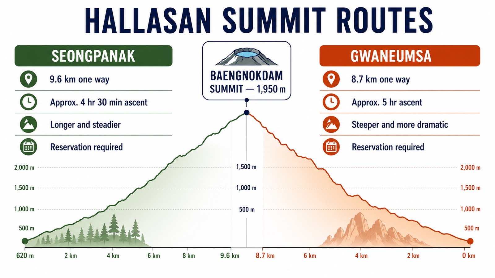
Both summit routes require a reservation through the Hallasan Trail Reservation System.
A popular arrangement is to ascend via Seongpanak and descend via Gwaneumsa, creating an approximately 18.3-kilometre traverse. This avoids repeating the same scenery but creates a transport problem because the two trailheads are separate.
Planning the traverse
Before choosing the point-to-point option:
- confirm transport to the starting trailhead;
- check how to leave the finishing trailhead;
- do not leave a rental car at the wrong end;
- save both trailhead names in Korean;
- check the final admission and turnaround times.
Hallasan uses seasonal entry cut-offs. A reservation does not allow a late hiker to ignore checkpoint closure times.
Weather
Conditions near the summit can differ considerably from Jeju City or Seogwipo. Wind, cloud, rain and temperature changes can occur within the same day.
Carry:
- a waterproof outer layer;
- warm layers outside summer;
- sufficient water;
- food for a full hiking day;
- sun protection;
- footwear suitable for rock and uneven steps.
If Hallasan is the central purpose of a Jeju trip, keep at least one flexible day. Weather-related closure on the only available day can otherwise remove the main activity from the itinerary.
5. Jirisan Cheonwangbong: Best for a Demanding Mountain Day
Jirisan is better suited to experienced hikers than to travelers seeking a simple excursion from a major city. The park is extensive, trailheads are spread across several areas, and transport requires more planning than Bukhansan or Inwangsan.
Cheonwangbong, at approximately 1,915 metres, is the highest point on the Korean mainland. One of the most direct approaches begins at Jungsanri.
Route profile
- Approximate distance: 10–11 km return.
- Typical time: 7–9 hours.
- Difficulty: very hard.
- Terrain: sustained climbing, stone steps, forest and exposed upper sections.
- Best for: experienced hikers seeking a full mountain day.
The relatively moderate distance can be misleading because the ascent is steep. This is not a sensible route for someone whose longest recent walk was a flat city itinerary.
Day hike or overnight route
A strong and early hiker may complete the Jungsanri approach as a day hike. Longer traverses and overnight plans require more preparation.
National park shelters and certain facilities use separate reservations. Check availability through the Korea National Park Service reservation portal.
Do not plan to sleep informally on the mountain. Confirm shelter availability before building a multi-day route.
Getting there
Jinju or another regional transport hub can serve as an intermediate base, but the final connection to Jungsanri must be checked carefully. Early trail starts may require accommodation closer to the entrance or a pre-arranged taxi.
Jirisan is where the claim that all Korean hiking is easy by public transport stops being reliable.
6. Geumjeongsan: Best Mountain Hike in Busan
Geumjeongsan provides a mountain alternative to Busan’s beaches and coastal attractions. The route network combines forest, fortress walls, temples and viewpoints across the city.
A practical route begins at Beomeosa Temple, continues toward the North Gate of Geumjeongsanseong Fortress and then climbs toward Godangbong, the mountain’s highest peak.
Route profile
- Approximate distance: 6–8 km, depending on the descent.
- Time: around 3–4 hours.
- Difficulty: moderate to hard.
- Best for: temple culture, fortress history and mountain views over Busan.
- Reservation: not normally required.
The route can be adapted by returning to Beomeosa, descending toward another entrance or connecting with longer Galmaetgil sections. Because entrance and exit points may be far apart, decide on the descent before reaching the summit.
The official Visit Busan guide recommends starting at Beomeosa, continuing through the North Gate and climbing toward Godangbong.
Getting there
Take Busan Metro Line 1 to Beomeosa Station and connect with a local bus or taxi toward the temple entrance. The official guide currently references Bus 90, but verify the live route in a navigation app.
Beomeosa is an active Buddhist temple. Keep noise low and follow photography restrictions around religious buildings.
7. Jeju Olle Route 7: Best Coastal Alternative
Not every hiking trail in South Korea needs to end on a summit. The Jeju Olle network circles the island through villages, farmland, volcanic terrain and coastal landscapes.
Route 7 is one of the best-known coastal sections around Seogwipo. It offers a long walking day without the sustained ascent of Hallasan.
Route profile
- Approximate distance: around 17 km;
- Time: approximately 5–6 hours;
- Difficulty: moderate;
- Format: point-to-point;
- Reservation: not normally required.
Route alignments can change because of construction, weather damage or land-access arrangements. Check the current course through the Jeju Olle Foundation rather than following an old GPX file without verification.
Practical considerations
- save the current finish point before starting;
- check bus connections from the endpoint;
- carry water outside built-up sections;
- follow official arrows and ribbon markers;
- avoid exposed coastal sections during strong wind;
- do not enter private fields or unofficial shortcuts.
Jeju Olle is a better choice than Hallasan for travelers who want a long walk but do not want a steep summit day.
Hiking Reservations and Trail Closures
South Korea does not use one universal reservation rule.
Hallasan
Seongpanak and Gwaneumsa summit routes require advance reservation. Availability and checkpoint times are displayed through the official Hallasan system.
National park day hikes
Routes such as Bukhansan Baegundae and Seoraksan Ulsanbawi do not normally require a standard advance reservation, but access can still be limited because of:
- wildfire prevention periods;
- storms or heavy rain;
- ice and snow;
- rockfall;
- trail maintenance;
- crowd controls.
Shelters and overnight routes
Shelters, campsites and some specialist programs can require reservations through the KNPS booking system.
A screenshot from an old blog is not evidence that a trail will be open on the intended date.
Best Time for Hiking in South Korea
Spring: March to May
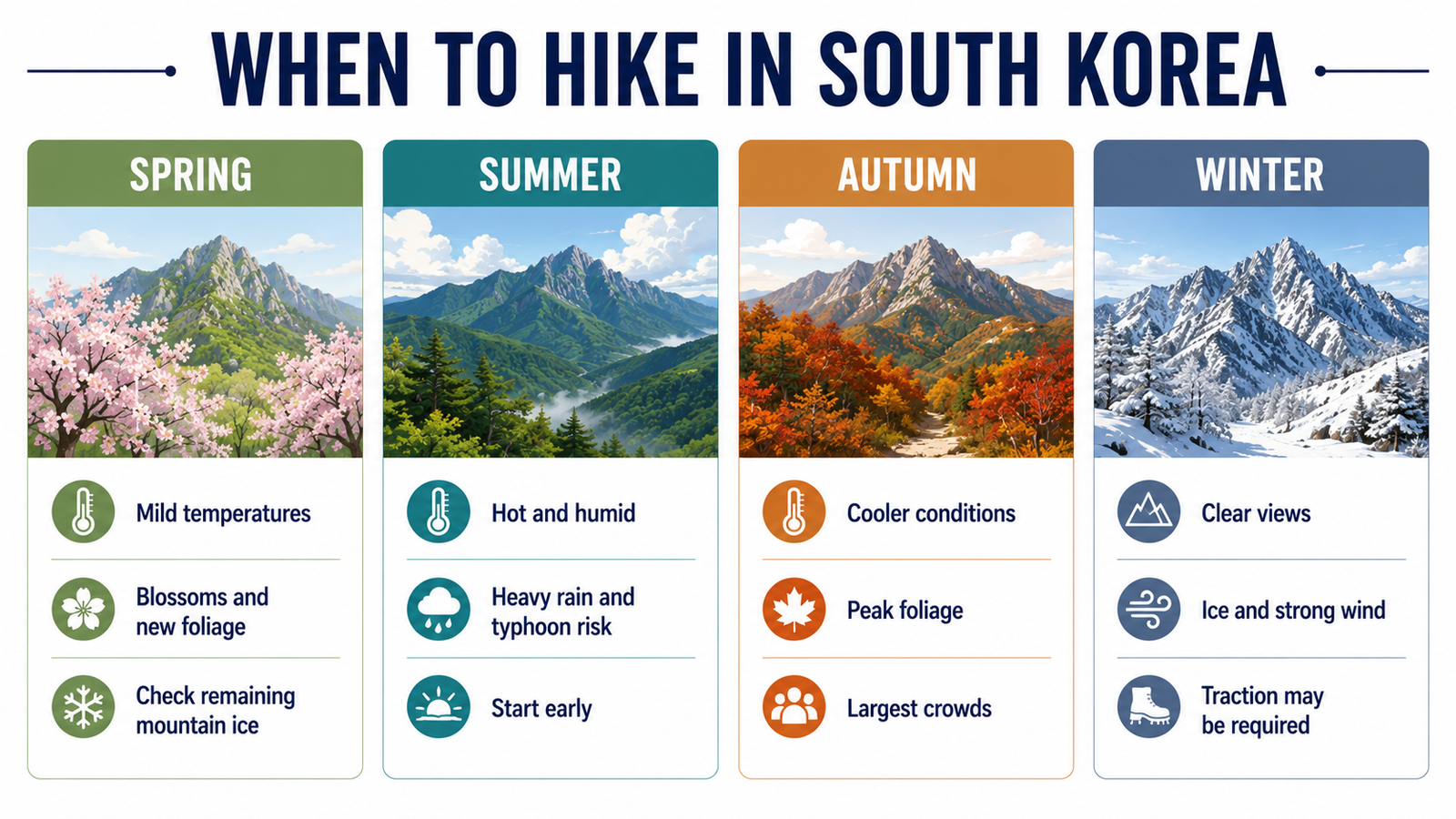
Spring offers moderate temperatures, blossoms and new foliage. Higher mountains may still have ice while cities already feel warm.
Check air quality and do not assume that blossom timing is identical between Seoul, Seoraksan and Jeju.
Summer: June to August
Summer hiking involves heat, humidity, heavy rain and possible typhoons. Start early, carry more water than usual and avoid exposed ridges during thunderstorms.
After intense rain, trails may remain slippery even when the city weather has improved.
Autumn: September to November
Autumn generally provides the most popular hiking conditions, particularly in Seoraksan, Jirisan and Naejangsan.
It also brings the largest crowds. Accommodation, intercity transport and park access roads can become congested during peak foliage weekends.
The South Korea Festivals Guide can help identify seasonal events competing for transport and accommodation.
Winter: December to February
Winter provides clearer views and quieter trails but requires appropriate equipment.
Depending on the route, hikers may need:
- microspikes;
- insulated gloves;
- wind-resistant layers;
- gaiters;
- a headlamp;
- extra battery capacity.
Do not use photographs of a snow-free Seoul street to judge conditions on an exposed mountain summit.
What to Pack for a Korea Day Hike
For a typical day route:
- stable hiking shoes;
- weatherproof outer layer;
- insulating layer;
- water;
- food and emergency snacks;
- sun protection;
- charged phone;
- offline or saved map;
- small first-aid kit;
- headlamp for longer routes;
- portable battery.
Convenience stores are useful before reaching the trailhead, but food and water should not be assumed available inside the park.
Pack out all rubbish, including tissues, fruit peel and food packaging.
Using Public Transport Without a Car
Public transport works particularly well for:
- Bukhansan;
- Inwangsan;
- Geumjeongsan;
- some Jeju Olle sections.
It requires more preparation for:
- Jirisan;
- early Hallasan starts;
- remote Seoraksan trailheads;
- routes finishing at a different entrance.
Naver Map and KakaoMap generally provide more useful local transport information than Google Maps in South Korea.
When planning, check four separate journeys:
- accommodation to the intercity terminal;
- intercity transport to the regional base;
- regional transport to the trailhead;
- transport from the finishing point.
A route is not practical merely because the first trailhead appears on a map.
For wider transport and regional planning, use the South Korea Travel Guide.
Hiking Safety and Trail Etiquette
Check the forecast through the Korea Meteorological Administration and the current park status before leaving.
Important rules:
- turn around before the official cut-off;
- do not cross closure barriers;
- allow descending time, not only ascent time;
- keep right where trail signs request it;
- give way on narrow or exposed sections;
- avoid loud music;
- do not feed wildlife;
- keep temples and memorial areas quiet;
- call 119 in an emergency.
Solo hiking is common on popular routes, but remoteness, weather and technical difficulty still matter. Share the intended route and return time with someone else.
For lower-impact planning, see the guide to sustainable travel in South Korea.